 -----------
We are looking for an angle to give to the satellite projection which will stop it from whirling around as the satellite goes over the pole. IDL likes the central meridian of the satellite projection to be vertical with North at the top. It does allow for a rotation of the central meridian using either the sat_p keyword, or as a third angle after lon and lat (map_set,lon,lat,new_angle,/satellite,...).
If the orbit inclination were exactly 90 degrees, this would be a little easier. But it's still not bad, as long as you know the exact position of the satellite. The sub-satellite lat and lon is not necessary, and if it were, the pointing problem would make this terrible. The important point is that the gci coordinates of the spacecraft have the north pole as the z-axis. These are stashed in the imageinfo structure, and I assume are accessible to the mapping codes Harald is using.
Simple cartoon 1 shows the orbit plane, the eliptical orbit, and the
gci coordinate system. X points to the Vernal Equinox, Z is the north pole,
Y=ZxX. The orbit plane is tipped such that it does not contain the z-axis.
For this example, the orbit plane contains the vernal equinox. The second
cartoon shows the projection of the orbit in the x-y plane. The spacecraft
x-y position is noted, and the angle which is indicated, that is the angle
we need.
-----------
Bad Cartoon #1---------------------------------------------------Bad Cartoon #2
That's simply the atan(imageinfo.o_gci(1),imageinfo.o_gci(0)). In the case shown, anyway. You would need to correct gci to gse (Lat and Local Time) to do it over days or month, of if you were worried about the one degree motion of the sun in gci every day.
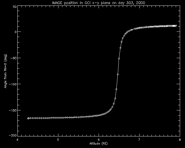
The next plot shows the change in this angle as IMAGE goes over
the north pole around 0200 UT. It changes by 180 degrees over the pole.
This angle, plus some correction, if fed to map_set, would probably do
the trick for movies.
Maybe this is all wrong, but it's worth a try, I think.